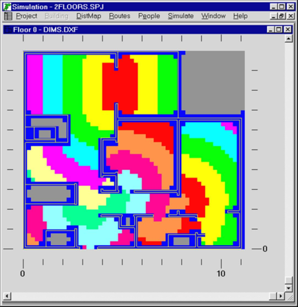
A ‘distance map’ consists of a mesh of 0.2 by 0.2m spatial blocks, which is used to represent a ‘low-resolution’ form of the total building space. The numerical value assigned to each block is equal to the total travel distance to an exit from that block. Simulex is able to calculate a distance map when at least one exit has been defined for a building.
Figure 6: Sample distance map
The distance maps are used by the program to direct the occupants to the closest available exit. The maps are calculated by the program before the simulation can start. Different distance maps (maximum 50), can be used with different exits being allowed for use by different occupants. This will allow the user to assign final destination exits to the occupants which are not necessarily the closest ones. This is described in more detail in the section Multiple distance maps.
When all the staircases and exits are in the right positions a distance map can be calculated. This will be executed by commands under the Menu: DistMap. Choose Calculate and indicate which distance map shall be calculated. The default distance map should always be available and should always be calculated even if it is never used. After confirmation with OK the distance map is calculated. Other distance maps can be defined under Setup and having other exits available to use. Whenever a building has changed (i.e. the status of any exit, link, staircase, or floor is altered) then each distance map must be recalculated.
The walking paths in the building can now be tested by using the commands under the Menu: Routes.